|
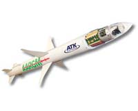
 Dynetics Completes Test On Multipurpose NanoMissile System Rocket Engine
Nashville TN (SPX) Jul 27, 2010 Dynetics has successfully completed a test firing series of the Multipurpose NanoMissile System (MNMS) first-stage demonstration booster being developed for the U.S. Army Space and Missile Defense Command/Army Forces Strategic Command (USASMDC/ARSTRAT). The series included a 60-second test of the 3,000 lbf nitrous oxide/ethane rocket engine. The MNMS booster was developed over 24 months with numerous rocket motor development tests. Dynetics is working with the USASMDC/ARSTRAT and COLSA Corpo ... read more |
. |
|
|
Free Space, Earth, Energy And Military Newsletters - Delivered Daily |
| . | . |
| .. |
 Edwards Air Force Base CA (SPX) Jul 21, 2010
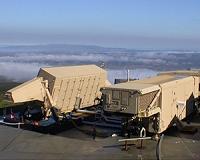
Northrop Grumman Corporation's first Block 40 RQ-4 Global Hawk high altitude long endurance (HALE) unmanned aircraft system (UAS) has completed envelope expansion flights, just six months after conducting its first flight. The Block 40 aircraft will be equipped with the high performance Multi-Platform Radar Technology Insertion Program (MP-RTIP) sensor and is the first of 22 Block 40 Globa ... more  Farnborough, UK (SPX) Jul 21, 2010
Raytheon Company has formed a team to include Rockwell Collins and Honeywell International to compete for JPALS Increment 2. JPALS is a civil and military precision landing system. It provides accurate, reliable landing guidance for fixed- and rotary-wing aircraft during all weather conditions. JPALS features anti-jam protection to assure mission continuity in a hostile environment. ... more  Denver CO (SPX) Jul 19, 2010
Intermap Technologies has announced at the ESRI International User Conference the full commercial availability of its NEXTMap USA countrywide digital mapping program. Uniformly accurate digital elevation models and images for the contiguous U.S. and Hawaii (approximately 8 million square kilometers) are now available via the company's Open Geospatial Consortium (OGC)-based cloud computing ... more |
.. |
 NASA Goddard Was In The Earthquake Zone  Art In Space - Or, How To Set Up A Formation  Instant online solar energy quotes Solar Energy Solutions from ABC Solar |
.. |
|
|
Free Space, Earth, Energy And Military Newsletters - Delivered Daily |

|
. |
 Caltech Scientists Measure Changing Lake Depths On Titan
Pasadena CA (SPX) Jul 16, 2010 On Earth, lake levels rise and fall with the seasons and with longer-term climate changes, as precipitation, evaporation, and runoff add and remove liquid. Now, for the first time, scientists have found compelling evidence for similar lake-level changes on Saturn's largest moon, Titan-the only other place in the solar system seen to have a hydrological cycle with standing liquid on the surface. Using data gathered by NASA's Cassini spacecraft over a span of four years, the researchers-led by gradu ... read more |
| The contents herein, unless otherwise known to be public domain, are Copyright 1995-2010 - SpaceDaily. AFP and UPI Wire Stories are copyright Agence France-Presse and United Press International. ESA Portal Reports are copyright European Space Agency. All NASA sourced material is public domain. Additional copyrights may apply in whole or part to other bona fide parties. Advertising does not imply endorsement, agreement or approval of any opinions, statements or information provided by SpaceDaily on any web page published or hosted by SpaceDaily. Privacy statement |
| Previous Issues | Jul 26 | Jul 23 | Jul 22 | Jul 21 | Jul 20 |