|
 High-Res Elevation Map Data For USA Now Available From Intermap Technologies
Denver CO (SPX) Jul 19, 2010 Intermap Technologies has announced at the ESRI International User Conference the full commercial availability of its NEXTMap USA countrywide digital mapping program. Uniformly accurate digital elevation models and images for the contiguous U.S. and Hawaii (approximately 8 million square kilometers) are now available via the company's Open Geospatial Consortium (OGC)-based cloud computing platform, TerrainOnDemand, and its worldwide network of distributors and strategic partners. The NEXTMap ... read more |
. |
|
|
Free Space, Earth, Energy And Military Newsletters - Delivered Daily |
| . | . |
| .. |
 Pasadena CA (JPL) Jul 07, 2010
As American schoolchildren head out to pools for a summer splash, NASA's Cassini spacecraft will be taking its own deep plunge through the Titan atmosphere this week. The altitude for the upcoming Titan flyby, whose closest approach occurs in the evening of July 6, Pacific and Eastern time (or shortly after midnight on July 7, Coordinated Universal Time) will be about 125 kilometers (78 mi ... more 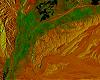 Bonn, Germany (SPX) Jul 06, 2010
From the ground, the famous Nazca lines in Peru don't look like much. It is only when you look at them from a height that the mysterious drawings on the stony desert floor come to life. The German Aerospace Center, TerraSAR-X radar satellite has seen them from space, providing a new view of this 2000-year-old World Heritage Site. The geoglyphs show up as dark grooves in the ground in the v ... more  New Orleans, Louisiana (AFP) July 5, 2010
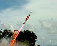
A US Navy airship was en route to the Gulf Coast on Monday to help recover the massive oil spill fouling once-pristine shorelines, officials said. The MZ-3A Airship, the first to be used in the massive response to the worst environmental disaster in US history, was expected to reach the Gulf Coast on Tuesday, depending on weather conditions, the Joint Unified Command overseeing the efforts s ... more |
.. |
 US, Poland sign modified missile shield deal  Iran moves radar to Syria: US official  Instant online solar energy quotes Solar Energy Solutions from ABC Solar |
.. |
|
|
Free Space, Earth, Energy And Military Newsletters - Delivered Daily |

|
. |
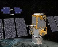
 CryoSat-2 Exceeding Expectations
Bergen, Norway (ESA) Jul 02, 2010 Today, participants at the Living Planet Symposium have been hearing about ESA's most recently launched mission, CryoSat-2. In orbit for almost three months, the satellite is in excellent health with scientists very encouraged by the first ice-thickness data presented at the symposium. Prof. Duncan Wingham, Lead Investigator for the CryoSat mission, stated, "The satellite is in very good shape - exceeding in-orbit specifications, the ground segment software is fine, the system of data distribution ... read more |
| The contents herein, unless otherwise known to be public domain, are Copyright 1995-2010 - SpaceDaily. AFP and UPI Wire Stories are copyright Agence France-Presse and United Press International. ESA Portal Reports are copyright European Space Agency. All NASA sourced material is public domain. Additional copyrights may apply in whole or part to other bona fide parties. Advertising does not imply endorsement, agreement or approval of any opinions, statements or information provided by SpaceDaily on any web page published or hosted by SpaceDaily. Privacy statement |
| Previous Issues | Jul 19 | Jul 16 | Jul 15 | Jul 14 | Jul 13 |