|
 TanDEM-X Delivers First 3D Images
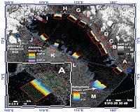
Bonn, Germany (SPX) Jul 23, 2010 On 22 July 2010, researchers at the German Aerospace Center facility in Oberpfaffenhofen published the first 3D images from the TanDEM-X satellite mission. Just one month after the launch of TanDEM-X, which took place on 21 June 2010, DLR researchers have created the first digital elevation model - almost a week ahead of schedule. A group of Russian islands in the Arctic Ocean was selected for the first test. b>Precise to a few centimetres br> /b> This first elevation model shows amazing v ... read more |
. |
|
|
Free Space, Earth, Energy And Military Newsletters - Delivered Daily |
| . | . |
| .. |
 Denver CO (SPX) Jul 19, 2010
Intermap Technologies has announced at the ESRI International User Conference the full commercial availability of its NEXTMap USA countrywide digital mapping program. Uniformly accurate digital elevation models and images for the contiguous U.S. and Hawaii (approximately 8 million square kilometers) are now available via the company's Open Geospatial Consortium (OGC)-based cloud computing ... more 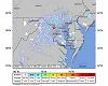 Washington DC (SPX) Jul 19, 2010
A small earthquake, centered in Germantown, Md. occurred at 5:04 a.m. EDT, July 16 and its vibrations were felt from West Virginia to Bridgeport, Conn. NASA's Goddard Space Flight Center located in Greenbelt, Md., lies about 25 miles east-southeast of the small earthquake and reported no damages. In fact, there were no reports of damage throughout Maryland. The earthquake registered 3.6 on ... more 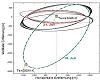 Bonn, Germany (SPX) Jul 19, 2010
On its launch date, 21 June 2010, roughly 16,000 kilometres separated TanDEM-X from its twin satellite, TerraSAR-X. Now, that distance has shrunk to just 2000 kilometres. The time has come for the relative movement between the two satellites to be slowed down, and for them to be set up for formation flying. To accomplish this, the Flight Dynamics Group at the German Space Operations Center ... more |
.. |
 Caltech Scientists Measure Changing Lake Depths On Titan  See Beautiful Ontario Lacus: Cassini's Guided Tour  Instant online solar energy quotes Solar Energy Solutions from ABC Solar |
.. |
|
|
Free Space, Earth, Energy And Military Newsletters - Delivered Daily |

|
. |
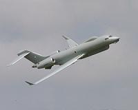
 India's Astra tested for night operations
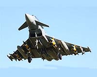
New Delhi (UPI) Jul 15, 2010 India has successfully test-fired an indigenously developed Astra air-to-air missile under poor weather conditions during the day and night. It was the first night test firing and also the first inclement weather launch, for an Astra, the missile's main development agency Defense Research and Development Organization said. The test from a launcher was conducted at the Integrated Test Range at Chandipur, around 140 miles from the Orissa state capital Bhubaneswar. Project Astra is p ... read more |
| The contents herein, unless otherwise known to be public domain, are Copyright 1995-2010 - SpaceDaily. AFP and UPI Wire Stories are copyright Agence France-Presse and United Press International. ESA Portal Reports are copyright European Space Agency. All NASA sourced material is public domain. Additional copyrights may apply in whole or part to other bona fide parties. Advertising does not imply endorsement, agreement or approval of any opinions, statements or information provided by SpaceDaily on any web page published or hosted by SpaceDaily. Privacy statement |
| Previous Issues | Jul 23 | Jul 22 | Jul 21 | Jul 20 | Jul 19 |