| April 28, 2009 |  |
RadarDaily Advertising Kit |
|
G/ATOR Critical Design Review Completed Baltimore MD (SPX) Apr 28, 2009 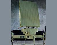 The U.S. Marine Corps' Ground/Air Task Oriented Radar (G/ATOR) program passed a key milestone with the successful conclusion of its formal Critical Design Review (CDR) at Northrop Grumman's Electronic Systems sector headquarters. "Radar technology represents the next generation of critical air and ground warfighting capabilities for Marine Corps and Joint Force Commanders," said John Burro ... read more
|
| |||||||||||||||
| Previous Issues | Apr 27 | Apr 24 | Apr 23 | Apr 22 | Apr 21 |
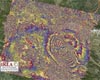
Radar Engineers Aid Largest National Tornado Study Amherst MA (SPX) Apr 28, 2009
As part of the largest, most ambitious attempt ever launched to figure out how tornadoes form and how to predict them more accurately, engineers from the University of Massachusetts Amherst this week are readying two special mobile Doppler radar systems for deployment to the Great Plains. The national project known as Verification of the Origins of Rotation in Tornadoes Experiment 2, or VO ... more A Glimpse Of Future GMES Sentinel-1 Radar Images 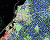 Paris, France (ESA) Apr 27, 2009
A newly initiated campaign marks an important step in preparing for how data from the Sentinel-1 European Radar Observatory will be used for applications such as land-cover mapping and crop management. Sentinel-1 is the first of the five missions that ESA is developing for the GMES initiative. Sentinel-1 is a constellation of two C-band radar satellites that will provide continuous all-wea ... more TerraSAR-X Image Of The Month: The Wadden Sea In North Frisia 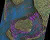 Bonn, Germany (SPX) Apr 24, 2009
The image shows the mudflats near the island of Sylt. It was compiled from two satellite images that were taken by the German radar satellite TerraSAR-X in April and May 2008. The individual pictures are coloured red and green respectively. The difference in the reflected radar signals is especially large over the areas of water, as it is here that there were the most changes between when ... more Raytheon Wins Program For Detection Of Land Mines And Tunnels  El Segundo CA (SPX) Apr 27, 2009
Raytheon Company has received a $19 million contract from the Defense Advanced Research Projects Agency for development and demonstration of technology to detect and locate buried land mines and tunnels. In Raytheon's plan, a laser radar vibration sensor, or ladar vibrometer, would reveal hidden targets by measuring ground-surface vibrations and use electronic instructions for calculation ... more A Glimpse Of Future GMES Sentinel-1 Radar Images  Paris, France (ESA) Apr 24, 2009
A newly initiated campaign marks an important step in preparing for how data from the Sentinel-1 European Radar Observatory will be used for applications such as land-cover mapping and crop management. Sentinel-1 is the first of the five missions that ESA is developing for the GMES initiative. Sentinel-1 is a constellation of two C-band radar satellites that will provide continuous all-wea ... more |
radar:
 abm:  radar: 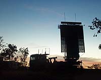 |
 Paris, France (ESA) Apr 20, 2009
Studying satellite radar data from ESA's Envisat and the Italian Space Agency's COSMO-SkyMed, scientists have begun analysing the movement of Earth during and after the 6.3 earthquake that shook the medieval town of L'Aquila in central Italy on 6 April 2009. Scientists from Italy's Istituto per il Rilevamento Elettromagnetico dell' Ambiente (IREA-CNR) and the Istituto Nazionale di Geofisic ... more PSLV Launches RISAT-2 And ANUSAT Satellites  Sriharikota, India (PTI) Apr 21, 2009
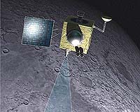
In its fifteenth mission carried out from Satish Dhawan Space Centre SHAR (SDSC SHAR), Sriharikota, ISRO's Polar Satellite Launch Vehicle (PSLV-C12) successfully placed two satellites - RISAT-2 and ANUSAT - in the desired orbit. RISAT-2 is a Radar Imaging Satellite with the capability to take images of the earth during day and night as well as cloudy conditions. At the time of launch ... more India Launches Spy Satellite  Sriharikota, India (PTI) Apr 21, 2009
Giving a big boost to its defence surveillance capabilities, India on Monday successfully launched an all-weather Israeli-built spy satellite that will help security agencies keep a vigil on the country's borders. Indian space agency ISRO's workhorse, PSLV-C12 rocket soared majestically into a clear sky at 6.45 am from the spaecport here and placed its first Radar Imaging Satellite (RISAT2 ... more RISAT2 Can See Through Thick Clouds  Sriharikota, India (PTI) Apr 21, 2009
India's newest eye in the sky, Radar Imaging Satellite-II (RISAT2), the first spy satellite launched from the spaceport here on Monday, has the capability to maintain vigil on the country's borders even at night and through clouds. The satellite, built with Israeli cooperation, enhances significantly India's capabilities in earth observation as it can track minute movements on land, source ... more Northrop Grumman Upgrades Ship Navigation Radars With Enhanced Naval Display Features  Charlottesville VA (SPX) Apr 20, 2009
Northrop Grumman Sperry Marine business unit announces the introduction of a new family of navigation radar sets with enhanced naval display features. "We are now offering a naval display version of our highly successful commercial VisionMaster FT series of navigation radars, providing extended capabilities to meet the specific requirements of naval ships," said J. Nolasco DaCunha, vice pr ... more |
lunar:
 iran: 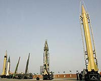 terrorwars:  satellite-tech: 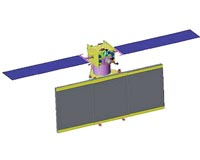 |
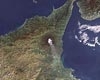 Paris, France (ESA) Mar 30, 2009
Using radar images acquired by ESA satellites from 1992 to 2006, scientists have for the first time been able to monitor the long-term behaviour of Mt. Etna, Europe's highest and most active volcano. This unprecedented time series of Synthetic Aperture Radar (SAR) observations from ESA's ERS-1, ERS-2 and Envisat satellites provided crucial information for understanding how the volcano's su ... more India Set To Launch Imaging Satellite With Israeli Support 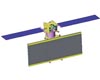 Bangalore, India (PTI) Mar 23, 2009
India is all set to launch a radar imaging satellite (RISAT) built with "substantial inputs" from the Israel aerospace industry from Sriharikota spaceport, an ISRO official said. Israel has supplied Synthetic Aperture Radar (SAR), which is in fact "heart" of the 1780-kg remote sensing satellite, the official told PTI on condition of anonymity. "Israel has supplied substantial systems," the ... more Infoterra To Map And Classify Oil Slicks Over Baffin Bay Greenland  Paris, France (SPX) Mar 23, 2009
Infoterra has been appointed to undertake an oil slick mapping and interpretation project over Baffin Bay for Nunaoil, the National Oil Company of Greenland. This project will begin in July and extend through to October, with the acquisition of approximately 480 radar satellite images over the 240,000 km2 area. Infoterra's team of experts will characterise and rank all oil slicks as ... more Czech opposition to US missile system grows: poll  Prague (AFP) March 19, 2009
Czech opposition to the installation of a US anti-missile radar system in their country has grown, as a record 70 percent now reject the project, a poll showed Thursday. Only 25 percent of those polled back the project, according to the survey conducted by the official polling institute CVVM in February. In January, 65 percent opposed the plan, which has angered Russia. "Results sinc ... more Czech PM defers ratification of US missile shield 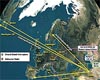 Prague (AFP) March 17, 2009
Czech Prime Minister Mirek Topolanek said his government was deferring a vote on a controversial US missile shield due on Tuesday in parliament amid fears that it could be rejected. "The government has decided to withdraw the two pacts with the United States on setting up a radar station on Czech soil," he said in a brief statement on state television. The treaty was due to be ratified ... more
|
gps:
 abm: 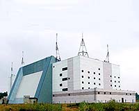 naval:  tectonics: 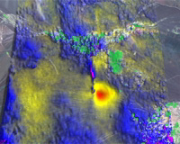 |
|
| Previous Issues | Apr 27 | Apr 24 | Apr 23 | Apr 22 | Apr 21 |
| The contents herein, unless otherwise known to be public domain, are Copyright 1995-2007 - SpaceDaily. AFP and UPI Wire Stories are copyright Agence France-Presse and United Press International. ESA Portal Reports are copyright European Space Agency. All NASA sourced material is public domain. Additional copyrights may apply in whole or part to other bona fide parties. Advertising does not imply endorsement, agreement or approval of any opinions, statements or information provided by SpaceDaily on any web page published or hosted by SpaceDaily. Privacy statement |