 |
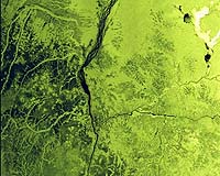
Sriharikota, India (PTI) Apr 21, 2009 India's newest eye in the sky, Radar Imaging Satellite-II (RISAT2), the first spy satellite launched from the spaceport here on Monday, has the capability to maintain vigil on the country's borders even at night and through clouds. The satellite, built with Israeli cooperation, enhances significantly India's capabilities in earth observation as it can track minute movements on land, sources said. Till now Indian satellites operated only in the visual range and RISAT2, for the first time, uses microwave frequencies to track the Earth. Though ISRO maintains that it will use the satellite for disaster management purposes and weather forecasts, the satellite imagery data can be made available to defence forces for securing the national borders. RISAT2 has all-weather capabilities to take images of the earth and would also be beneficial in mapping and helping in managing natural disasters, such as floods and landslides, they said. Different from previous remote sensing satellites, RISAT2 uses Synthetic Aperture Radar (SAR), equipped with many antennas, to receive signals that could be processed into high-resolution pictures. The SAR, developed by Israel Aerospace Industries, equips RISAT2 with defence capabilities, the sources said.
Source: Press Trust of India Share This Article With Planet Earth
Related Links ISRO Earth Observation News - Suppiliers, Technology and Application
 Paris, France (ESA) Apr 17, 2009
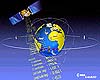
A rain of navigation signals falls constantly upon the Earth from GPS and the initial satellites in Europe's Galileo system, enabling an ever-increasing number of positioning and guidance services. |
|
| The content herein, unless otherwise known to be public domain, are Copyright 1995-2007 - SpaceDaily.AFP and UPI Wire Stories are copyright Agence France-Presse and United Press International. ESA Portal Reports are copyright European Space Agency. All NASA sourced material is public domain. Additional copyrights may apply in whole or part to other bona fide parties. Advertising does not imply endorsement,agreement or approval of any opinions, statements or information provided by SpaceDaily on any Web page published or hosted by SpaceDaily. Privacy Statement |
 del.icio.us
 Digg
Digg Reddit
 YahooMyWeb
 Google