 |
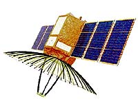
Sriharikota, India (PTI) Apr 21, 2009 Giving a big boost to its defence surveillance capabilities, India on Monday successfully launched an all-weather Israeli-built spy satellite that will help security agencies keep a vigil on the country's borders. Indian space agency ISRO's workhorse, PSLV-C12 rocket soared majestically into a clear sky at 6.45 am from the spaecport here and placed its first Radar Imaging Satellite (RISAT2) and micro-educational satellite ANUSAT into orbit about 19 minutes later in a textbook launch. The 300-kg RISAT2 will primarily keep an eye on the country's borders round-the-clock and help in anti-infiltration and anti-terrorist operations. A jubilant ISRO Chairman G. Madhavan Nair said "the year 2009 has started off well. The final moments of the launch were more thrilling than a cricket match as we hit a few boundaries and bowled some googlies." Mr. Nair said the performance of the PSLV-C12 launch vehicle was "precise and on the dot." He added: "Again, we have set a record. As in the past, we declared the launch date, time and we made it happen." He said RISAT2 would be a good asset to national resources and "I am sure it is going to serve the country well." RISAT2 has all-weather capabilities to take images of Earth and would also be beneficial in mapping and managing natural disasters, such as floods and landslides. The 40-kg micro satellite ANUSAT, the co-passenger of RISAT2, has been built by Anna University, to demonstrate the technologies related to message store and forward operations. ANUSAT, the first built by an Indian University, is a 'store-and-forward' communication satellite that will help transfer confidential academic material and also monitor drought and wasteland, urban planning and other studies. RISAT2 has a lifespan of three years and ANUSAT one year. Different from previous remote sensing satellites, RISAT2 uses Synthetic Aperture Radar (SAR), equipped with many antennas, to receive signals which are processed into high-resolution pictures. The SAR, developed by Israel Aerospace Industries, equips RISAT with defence capabilities. The SAR payload can take images during day, night and in all weather conditions, including under cloud cover, a capability that Indian satellites do not have. Mr. Nair said ISRO has "big goals" to achieve this year, referring to the line up of ISRO launches. "All this put together... it is going to be almost like the fireworks season at Sriharikota." Monday's is the 15th flight of PSLV, which has so far launched 30 satellites - 14 for India and 16 for othercountries - since 1993. PSLV had also launched the Chandrayaan-1 spacecraft on October 22, 2008.
Source: Press Trust of India Share This Article With Planet Earth
Related Links ISRO Military Space News at SpaceWar.com
 Kirtland AFB NM (AFNS) Apr 20, 2009
Providing up-to-the-minute data to the in-theater commander can act as the tipping point to achieve success on the battlefield, and demonstrating that capability has been planned for the Tactical Satellite-3's upcoming, year-long mission. |
|
| The content herein, unless otherwise known to be public domain, are Copyright 1995-2007 - SpaceDaily.AFP and UPI Wire Stories are copyright Agence France-Presse and United Press International. ESA Portal Reports are copyright European Space Agency. All NASA sourced material is public domain. Additional copyrights may apply in whole or part to other bona fide parties. Advertising does not imply endorsement,agreement or approval of any opinions, statements or information provided by SpaceDaily on any Web page published or hosted by SpaceDaily. Privacy Statement |
 del.icio.us
 Digg
Digg Reddit
 YahooMyWeb
 Google