|
 Eyes In The Sky Give India Edge In Space
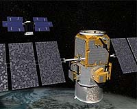
Chennai, India (PTI) Jul 14, 2010 With the successful launch of Cartosat-2B on Monday, India has reached a `critical constellation' of 10 active remote sensing satellites in space, which gives it a clear edge in the region for monitoring borders and movements across them. While mapping and infrastructure development are seen as primary applications of a remote sensing satellite, its use in spying is often underplayed. A combination of four Cartosats (1,2,2A and 2B) hovering 630 km above earth allows India to keep areas under close ... read more |
. |
|
|
Free Space, Earth, Energy And Military Newsletters - Delivered Daily |
| . | . |
 |
| .. |
 Palmahim Air Base, Israel (AFP) July 1, 2010
The eyes in the sky of modern warfare, whose hallmark hum is heard over Afghanistan, Iraq and Gaza, drones are a key weapon and a major cash earner for Israel, the world's largest exporter of pilotless planes. With more than 1,000 Unmanned Aerial Vehicles (UAVs) sold, Israel has raked in several hundred million dollars over the years. Israel's fleet ranges from aircraft which fit in a so ... more  Dallas TX (SPX) Jun 30, 2010
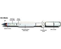
The Missile Defense Agency and Lockheed Martin conducted a successful flight test of the Terminal High Altitude Area Defense (THAAD) Weapon System at the Pacific Missile Range Facility on Kauai, HI. This flight test was THAAD's seventh intercept to date and proved the system's ability to intercept a unitary target in the low endo-atmosphere. There were many THAAD flight test program "first ... more  Bonn, Germany (SPX) Jun 28, 2010
Already, with its first image acquisitions, TanDEM-X (TerraSAR-X add-on for Digital Elevation Measurement) has surpassed its twin satellite, TerraSAR-X. On 24 June 2010, only 3 days and 14 hours into the mission, the satellite sent its first image data back to Earth. The transmission was received by the German Aerospace Center ground station at Neustrelitz and processed to produce images. ... more |
.. |
 Northrop Grumman Discusses Capabilities in Electronic Warfare Interoperability  USS George H.W. Bush Conducts First Missile Launch  Instant online solar energy quotes Solar Energy Solutions from ABC Solar |
.. |
|
|
Free Space, Earth, Energy And Military Newsletters - Delivered Daily |

|
. |
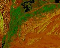
 NASA Radar Images Show How Mexico Quake Deformed Earth
Pasadena CA (JPL) Jun 24, 2010 NASA has released the first-ever airborne radar images of the deformation in Earth's surface caused by a major earthquake - the magnitude 7.2 temblor that rocked Mexico's state of Baja California and parts of the American Southwest on April 4. The data reveal that in the area studied, the quake moved the Calexico, Calif., region in a downward and southerly direction up to 80 centimeters (31 inches). A science team at NASA's Jet Propulsion Laboratory, Pasadena, Calif., used the JPL-developed ... read more |
| The contents herein, unless otherwise known to be public domain, are Copyright 1995-2010 - SpaceDaily. AFP and UPI Wire Stories are copyright Agence France-Presse and United Press International. ESA Portal Reports are copyright European Space Agency. All NASA sourced material is public domain. Additional copyrights may apply in whole or part to other bona fide parties. Advertising does not imply endorsement, agreement or approval of any opinions, statements or information provided by SpaceDaily on any web page published or hosted by SpaceDaily. Privacy statement |
| Previous Issues | Jul 14 | Jul 13 | Jul 12 | Jul 09 | Jul 08 |