|
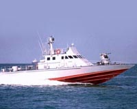
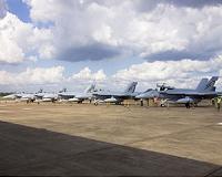
 First MEADS Intra-Fire Unit Communications Hardware Delivered
Orlando FL (SPX) Oct 26, 2010 Lockheed Martin recently delivered the first two intra-fire unit communications hardware components for the tri-national Medium Extended Air Defense System (MEADS). The two Message Routing Subsystem units are essential elements of the MEADS Internal Communications Subsystem (MICS) hardware, which will support the system-level integration and test of intra-fire unit communications for the air and missile defense system. MICS provides secure tactical communications between the MEADS major end ... read more |
. |
|
|
Free Space, Earth, Energy And Military Newsletters - Delivered Daily |
| . | . |
 DLR Becomes A Member Of The International Charter Space And Major Disasters The German Aerospace Center has become a member of the International Charter 'Space and Major Disasters'. At an event in Paris to celebrate the tenth anniversary of its founding, Johann-Dietrich Wor ... more | .. |
 The Satellites Have Eye Contact This is the moment we have been anticipating for a long time; TerraSAR-X and TanDEM-X finally have 'eye contact'. The final manoeuvre to adjust the close formation was performed on 13 October. Now, ... more | .. |
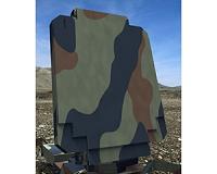 Preliminary Design for New Long-Range Surveillance Radar Completed The U.S. Air Force has approved Lockheed Martin's preliminary design for its next-generation mobile, long-range surveillance and ballistic missile defense radar. The Three-Dimensional Expediti ... more | .. |
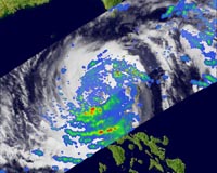 NASA Watches Typhoon Megi Dump Heavy Rain Typhoon Megi is now over the South China Sea as a Category 3 typhoon, gaining more strength after drenching the northern Philippines. NASA satellites saw the heavy rainfall and very high thunderstor ... more | .. |
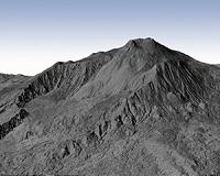
 Insight Into Volcanic Eruptions, Courtesy Of Space Scientists are crediting satellite imagery with helping to predict where volcanic eruptions could strike. It is well known that earthquakes can stress Earth's crust and trigger subsequent quakes, bu ... more |
|
Free Space, Earth, Energy And Military Newsletters - Delivered Daily |
| .. |
 Berlin, Germany (SPX) Oct 19, 2010
The Gulf of Mexico oil spill couldn't have occurred at a worse time for bluefin tuna: they had come to the area - a major spawning ground - to produce offspring. Satellites are helping assess the damage from the disaster on the fish's spawning habitat. The majestic Atlantic bluefin tuna, among the largest fish able to grow the size of a Volkswagen Beetle, come to the Gulf yearly from Janua ... more  Paris, France (ESA) Oct 18, 2010
Our view of Earth is set to become even sharper with new instruments to be carried on ESA's Sentinel-3 satellites. In many ways, it will be like looking at Earth through a new pair of glasses. Sentinel-3 is one of the five missions that ESA is developing for Europe's Global Monitoring for Environment and Security (GMES) initiative. Primarily, Sentinel-3 will deliver data for GMES services ... more  Paris (AFP) Oct 18, 2010
Numbers of juvenile Atlantic tuna at a major spawning site in the Gulf of Mexico probably fell by at least a fifth this year as a result of the BP oil spill, the European Space Agency (ESA) said Monday. The assessment comes from satellite images and data of the Gulf from April 20 to August 29, it said in a press release. The Atlantic tuna is a valuable commercial species that is in alarm ... more |
.. |
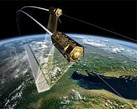 TerraSAR-X And TanDEM-X Flying In Close Formation  France, Germany offer hand to Russia at seaside summit  Instant online solar energy quotes Solar Energy Solutions from ABC Solar |
.. |
|
|
Free Space, Earth, Energy And Military Newsletters - Delivered Daily |

|
. |
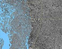
 Satellites join up to map Earth
Berlin (UPI) Oct 15, 2010 Two German satellites orbiting within 380 yards of each other are preparing to create the most detailed map ever made of Earth's entire surface, officials said. The radar satellites TanDEM-X and TerraSAR-X will make 3-D maps of the surface as they orbit the globe, sweeping around the planet at more than 14,000 mph, the BBC reported. TerraSAR-X was launched in 2007 and TanDEM-X was put in orbit in June, then slowly brought closer and closer to its companion. The final maneuvers to ... read more |
| The contents herein, unless otherwise known to be public domain, are Copyright 1995-2010 - SpaceDaily. AFP and UPI Wire Stories are copyright Agence France-Presse and United Press International. ESA Portal Reports are copyright European Space Agency. All NASA sourced material is public domain. Additional copyrights may apply in whole or part to other bona fide parties. Advertising does not imply endorsement, agreement or approval of any opinions, statements or information provided by SpaceDaily on any web page published or hosted by SpaceDaily. Privacy statement |
|
Free Space, Earth, Energy And Military Newsletters - Delivered Daily |
| Previous Issues | Oct 26 | Oct 25 | Oct 22 | Oct 21 | Oct 20 |